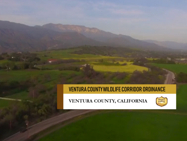
WILDLIFE IN VENTURA COUNTY – LOS PADRES NATIONAL FOREST
Wildlife in Ventura County – Los Padres National Forest
There is a proposal for new restrictions and regulations covering 420,000 acres, approximately 30% of
Ventura County and including 164,000 acres of private and public land.
What is being left out, and perhaps what most people are not aware of is the fact that in the mountains and hills behind Ventura, and stretching for 220 miles from Northern Los Angeles County to Monterey County sits the Los Padres National Forest, encompassing almost 1, 750, 000 acres of which 48% is designated as wilderness. These 10 wilderness areas comprise of 875,000 acres.
The second largest forest in California, the Los Padres’ 1,750,000 million acres encompasses the Central California coast and Transverse Ranges. Elevations range from sea level to almost 9,000 feet. There are a wide range of ecosystems supporting a diverse wildlife habitat within the Los Padres National Forest providing permanent or transitory refuge for approximately 468 species of fish and wildlife, of which most are nongame species.
Since California was first settled, farmers and ranchers have coexisted with wildlife. This new corridor area proposed in Ventura county, will not protect wildlife further, instead it will place significant restrictions on land owners, including farmers, ranchers, and horse enthusiasts. The wildlife in Ventura county are already protected in the nearby Los Padres National Forest and Wilderness areas.
Essentially the Wildlife Corridor ordinance is a conservation easement with no compensation to land owners. It does not provide any allowances for the individual needs of families who own and pay taxes on Ventura County properties.
If you are concerned about this proposed Wildlife Corridor, the changes that will be made to existing zoning, the new restrictions and regulations imposed on landowners and the threat to public safety, your voice needs to be heard.
BOARD OF SUPERVISORS MEETING
TUESDAY, MARCH 12TH AT 1:00 PM
MAIN BOARDROOM, COUNTY GOVERNMENT CENTER, HALL OF ADMINISTRATION
800 S. Victoria Avenue, Ventura
For additional information about the meeting: Chris Collier 805-766-4444 – chris.collier@rinconstrategies.com
ADDITIONAL INFORMATION
30% OF VENTURA COUNTY IS FACING PROHIBITIVE AND DANGEROUS REGULATIONS –
THE VENTURA COUNTY WILDLIFE CORRIDOR AND ITS IMPACT – MORE THAN PUBLIC LANDS
In January 2017, in a 3-2 vote, the Ventura County Board of Supervisors advised the Planning Division to study potential new restrictions and regulations covering 420,000 acres, approximately 30% of Ventura County. This includes 164,000 acres of both public and private property that cuts through the heart of Ventura County, naming it the Habitat Connectivity and Wildlife Movement Corridors. Then, in August of 2018, the County of Ventura proposed to add additional restrictions and regulations.
What Ventura County residents need to know is that the County Board of Supervisors is moving fast. They are pushing to implement the Wildlife Corridor zoning ordinance and its related land use restrictions and regulations in March of 2019.
NEW REGULATIONS AND RESTRICTIONS WILL DEVASTATE LOCAL FAMILIES AND FARMS AND RESTRICT PUBLIC USE
The Ventura County Supervisors plan to create a Habitat Connectivity Wildlife Corridor Overlay Zone which imposes a myriad of new regulations and restrictions for landowners. Within that zone they would identify additional overlay areas and title them “Critical Wildlife Passage Areas” that includes even more restrictions.
Essentially Ventura County properties could be subject to 3 sets of zoning regulations:
• The base set of zoning regulations depending on category for example, residential, commercial, rural, agricultural
• The Habitat Connectivity and Wildlife Movement Corridor zone
• The Critical Wildlife Passage Areas
The impact of this on landowners and the community will be devastating.
The new restrictions and regulations on both public and private property encompass:
• Fencing, installation or replacement
• Lighting, installation or replacement including removal of existing lighting no longer permitted under the conditions of the new ordinance. Other lighting restrictions will be enforced including height, direction, color and hours
• Eliminating non-native invasive plants
• Restricting vegetation removal, including fire prevention and mitigation measures
• Designation of wildlife passage areas across farmland with no scientific studies
• Building of new structures and fencing on properties in the Wildlife Passage Areas would require environmental analysis or setting aside half of the land to revert to its natural state for wildlife habitat
• Awarding the Planning Director the discretionary power to control (and even deny) every aspect of basic property improvements that are not specifically exempt from the ordinance
• Requiring land owners to undergo a full environmental analysis of projects including, houses, barns, lighting and fences before approval
• Expanding the size of “surface water area buffer zones” rendering many properties virtually unusable
• Conditional Use Permits will be in jeopardy of non-renewal once they expire
• Preventing land owners from making improvements or rebuilding property like fencing, barns and homes if damaged by fire or other natural disasters
THREAT OF INCREASED WILDFIRES IMPACTS PUBLIC SAFETY
New restrictive regulations preventing landowners from conducting fire prevention measures will increase the already dangerous threat of devastating wildfires. For reference, the Thomas, Hill and Woolsey fires scorched over 383,000 acres and burned over 3,183 structures. The recent fires destroyed wildlife populations and their habitat. The National Park Service estimates that the Santa Monica Mountains lost half of its habitat in the fire, burning 100,000 acres or 88 percent of the area’s federal parkland.
WILDLIFE CRITICAL PASSAGE AREAS – VAGUE REGULATIONS
The lack of clarity in these regulations would result in projects, from simply installing fencing to planting crops in the county, be subject to the discretion of the County Planning Director.
WILDLIFE ALREADY TRAVELS THROUGH MANY AREAS OF VENTURA COUNTY
It is important to note that the original Wildlife Corridor zoning proposal was designed to maintain existing wildlife passage points, not to create new ones.
NO COMPENSATION TO LAND OWNERS
ssentially the Wildlife Corridor ordinance is a conservation easement with no compensation to land owners. It does not provide any allowances for the individual needs of families who own and pay taxes on Ventura County properties.
OUT OF DATE DATA IS BEING UTILIZED
Many of the recommendations for the Wildlife Corridor are based off of studies and models conducted over 13 years ago. As an example, there is a corridor indicated on the new zoning map that fully encompasses the Bell Canyon subdivision.
LANDOWNERS TO BEAR THE EXPENSE OF OUT OF DATE MAPS
A Surface Water Overlay map has been created showing how 200 foot “buffer zones” overlay properties within the Wildlife Corridor in Ventura County. However, the map includes man-made features, for example ponds and swimming pools that were purposely excluded in the ordinance language from new “wildlife buffer zones”. Landowners will have to pay County planners and consultant biologists to remove unintended restrictions on their land.
EMAIL YOUR CONCERNS
You can also send an email to the Ventura County Board of Supervisors expressing your concerns: clerkoftheboard@ventura.org
HOW CAN I HELP? – VOLUNTEER OR DONATE TO VENTURA COUNTY COLAB
Ventura County CoLab is a non-profit organization of farmers, ranchers, business professionals and experts collaborating to promote sensible and rational government in Ventura County. VC CoLab supports land stewardship and preservation of economic livelihoods. CoLAB Ventura County provides a funded, full-time local presence to balance environmental, regulatory and economic concerns. Our efforts include monitoring local public agencies and elected boards where we commonly testify on regulatory issues. We cooperate with the COLAB groups in Santa Barbara and San Luis Obispo Counties forming a tri-county force.
Your support of time or donations can help to ensure that Ventura County remains a family and farm friendly community.
LINKS TO ADDITIONAL INFORMATION
Wildlife Corridor Regulations: http://colabvc.org/wildlife-corridor/
Updated Ordinance 1-31-2018: http://colabvc.org/wp-content/uploads/2019/02/HCWC-Draft-Ordinance-Planning-Commission-Errata_Att-1-on-1-30-19.pdf
Link to Wildlife Corridor Map: http://colabvc.org/wp-content/uploads/2018/08/Regional-Wildlife-Corridor-Ventura-County-South-Half.png
Link to find your property on the Ventura County Website: https://rma.maps.arcgis.com/apps/webappviewer/index.html?id=92c5352af22a44a3a99dd41aa1b8d567